


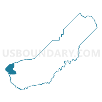
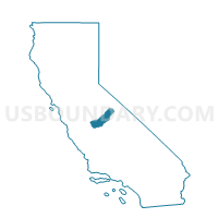
Voting District 20155, Madera County, California
About
Outline

Summary
| Unique Area Identifier | 534740 |
| Name | Voting District 20155 |
| County | Madera County |
| State | California |
| Area (square miles) | 56.00 |
| Land Area (square miles) | 55.42 |
| Water Area (square miles) | 0.59 |
| % of Land Area | 98.95 |
| % of Water Area | 1.05 |
| Latitude of the Internal Point | 37.03924070 |
| Longtitude of the Internal Point | -120.45753740 |
Maps

Graphs
Select a template below for downloading or customizing gragh for Voting District 20155, Madera County, California


Neighbors
Neighoring Voting District (by Name) Neighboring Voting District on the Map
- Voting District 10040, Merced County, CA
- Voting District 10050, Merced County, CA
- Voting District 11345, Fresno County, CA
- Voting District 20150, Madera County, CA
- Voting District 20190, Madera County, CA
- Voting District 20265, Madera County, CA
- Voting District 20270, Madera County, CA
- Voting District 50540, Merced County, CA
- Voting District 50555, Merced County, CA
Top 10 Neighboring County Subdivision (by Population) Neighboring County Subdivision on the Map
- Merced CCD, Merced County, CA (99,537)
- Chowchilla CCD, Madera County, CA (23,371)
- Dos Palos CCD, Merced County, CA (9,261)
- Firebaugh CCD, Fresno County, CA (9,143)
- Madera West CCD, Madera County, CA (1,288)
Top 10 Neighboring Elementary School District (by Population) Neighboring Elementary School District on the Map
- Chowchilla Elementary School District, CA (21,902)
- Alview-Dairyland Union Elementary School District, CA (1,787)
- El Nido Elementary School District, CA (1,682)
- Plainsburg Union Elementary School District, CA (444)
Top 10 Neighboring Secondary School District (by Population) Neighboring Secondary School District on the Map
- Merced Union High School District, CA (166,634)
- Chowchilla Union High School District, CA (23,689)
- Le Grand Union High School District, CA (8,218)
Top 10 Neighboring Unified School District (by Population) Neighboring Unified School District on the Map
- Madera Unified School District, CA (87,841)
- Dos Palos-Oro Loma Joint Unified School District, CA (10,449)
Top 10 Neighboring State Legislative District Lower Chamber (by Population) Neighboring State Legislative District Lower Chamber on the Map
- Assembly District 17, CA (510,960)
- Assembly District 31, CA (487,018)
- Assembly District 25, CA (475,252)
Top 10 Neighboring State Legislative District Upper Chamber (by Population) Neighboring State Legislative District Upper Chamber on the Map
- State Senate District 14, CA (1,020,927)
- State Senate District 16, CA (976,489)
- State Senate District 12, CA (955,935)
Top 10 Neighboring 111th Congressional District (by Population) Neighboring 111th Congressional District on the Map
- Congressional District 19, CA (757,337)
- Congressional District 20, CA (744,350)
- Congressional District 18, CA (723,607)
Top 10 Neighboring Census Tract (by Population) Neighboring Census Tract on the Map
- Census Tract 2.02, Madera County, CA (6,109)
- Census Tract 9.01, Merced County, CA (3,970)
- Census Tract 24.01, Merced County, CA (1,756)
- Census Tract 4, Madera County, CA (1,288)
- Census Tract 84.02, Fresno County, CA (1,152)